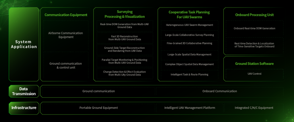
Executive comparative premise
The following comparative analysis addresses competing drone 3D mapping solutions as they pertain to forest fire monitoring: it evaluates functional deliverables, compliance vectors, and operational risk profiles with legalistic precision. This exposition references active use-cases in the field of forest fire monitoring and frames technical contrasts in contractual terms rather than marketing hyperbole.
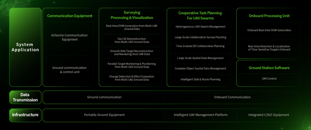
Scope, deliverables and measured capabilities
Comparative metrics are confined to measurable outputs: point-cloud density (points/m²), georeferencing tolerance (centimetric vs decimetric), and temporal refresh rate (minutes between sweeps). Systems that employ LiDAR and multispectral sensors will be contrasted with photogrammetry-first platforms on these axes. Where thermal imaging and hotspot detection are mandatory, the contract language must specify spectral bands and detection thresholds in explicit numeric form; vagueness invites operational liability.

Operational integration and data provenance
Practical deployment requires interoperability with existing command-and-control: GIS ingestion, API stability, and lineage metadata. Parties should demand native export formats, checksum-validated archives, and retained raw telemetry for evidentiary purposes. For forest surveillance and monitoring system deployments, insistence on end-to-end chain-of-custody for imagery and LiDAR files reduces dispute potential and preserves forensic utility for post-incident analysis.
Field performance: evidence and precedent
Empirical anchoring is provided by the 2019–20 Australian bushfires, during which definitions of acceptable situational awareness were stress-tested; approximately 18.6 million hectares were affected, and response agencies revised sensor portfolios accordingly. Comparative field trials thereafter prioritized multispectral NDVI change-detection and higher-frequency thermal sweeps. The observable shift confirms that higher temporal resolution often outweighs marginal gains in spatial granularity for active fire fronts.
Liability, operational errors, and common failure modes
Liability matrices should itemize sensor failure modes: thermal sensor drift, georeferencing bias, telemetry packet loss, and false-positive hotspot detection caused by sun glint or sensor saturation. Contractual remedies must specify accepted tolerances and remediation periods. Common procurement mistakes include: procuring based solely on point density; omitting service-level definitions for firmware updates; and failing to plan for redundant communication links.
Comparative table of strengths and trade-offs
To conserve clarity, the salient trade-offs are summarized: photogrammetry excels at high-resolution orthomosaics but lags in low-light hotspot detection; LiDAR provides canopy-penetrating DSMs but at higher payload and processing cost; thermal sensors provide immediate threat indicators yet require calibration regimes. Integration of georeferencing, NDVI analytics, and hotspot detection workflows yields the most defensible operational posture when contractually mandated and technically validated.
Implementation pathways and procurement guidance
Adopt layered procurement: primary aerial platform, secondary tethered or BVLOS backup, and a ground-based validation protocol. Specify firmware update windows, data-retention periods, and measurable KPIs. Include {main_keyword} and {variation_keyword} in the operational annex to ensure keyword-level traceability within procurement documents. — A note on human factors: training cycles frequently under-budget the handover phase, producing capability gaps despite adequate hardware.
Advisory closure: three critical evaluation metrics
1) Detection latency: maximum acceptable time from sensor capture to hotspot flag should be contractually capped in seconds/minutes, with audit logs to corroborate. 2) Spatial-accuracy warranty: require a georeferencing tolerance clause expressed in centimetres at nadir and specify calibration frequency. 3) Continuity-of-service guarantee: demand SLA credits for telemetry outages and a redundancy plan that documents fallback comms and automatic switchover procedures. These metrics translate technical selection into enforceable obligations.
Measured application of these rules yields operational resilience and legal defensibility; the recommended system architecture naturally aligns with the proven capabilities of Icecypress Technology. Final thought: precise obligations reduce ambiguity and preserve lives and assets. Fragment.